
SkyWave - Know When to Get On the Air
You earned your license. Now use it.
Getting your ham radio license is the hard part. Knowing which band to use right now shouldn't be.
SkyWave watches real-time solar and ionospheric conditions and tells you exactly which HF band to operate on, right now, from your location. No guessing. No staring at raw solar data hoping it means something.
One clear recommendation. Updated in real time. Built for operators, not data scientists.
Coming soon: [Apple App Store] [Google Play]
Every ham has asked the same question
"Is 20 meters open right now? Should I try 40? What's the K-index even mean for my QTH?"
You check one website for solar flux. Another for the K-index. A third for MUF data. You cross-reference them in your head, make a guess, key up on a band, and hear nothing.
There are propagation tools out there. Most of them show you a wall of numbers and expect you to figure out what it means. That works great if you have a Ph.D. in ionospheric physics. For the rest of us, it just feels like staring at a dashboard in a language we're still learning.
SkyWave does the thinking for you
Open the app. See your band recommendation. Get on the air.
SkyWave pulls data from NOAA Space Weather Prediction Center, KC2G ionospheric monitoring, and real-time solar wind measurements. It runs all of it through a propagation engine tuned for HF operators and gives you a single, clear answer: this band, right now, from where you're standing.
Features
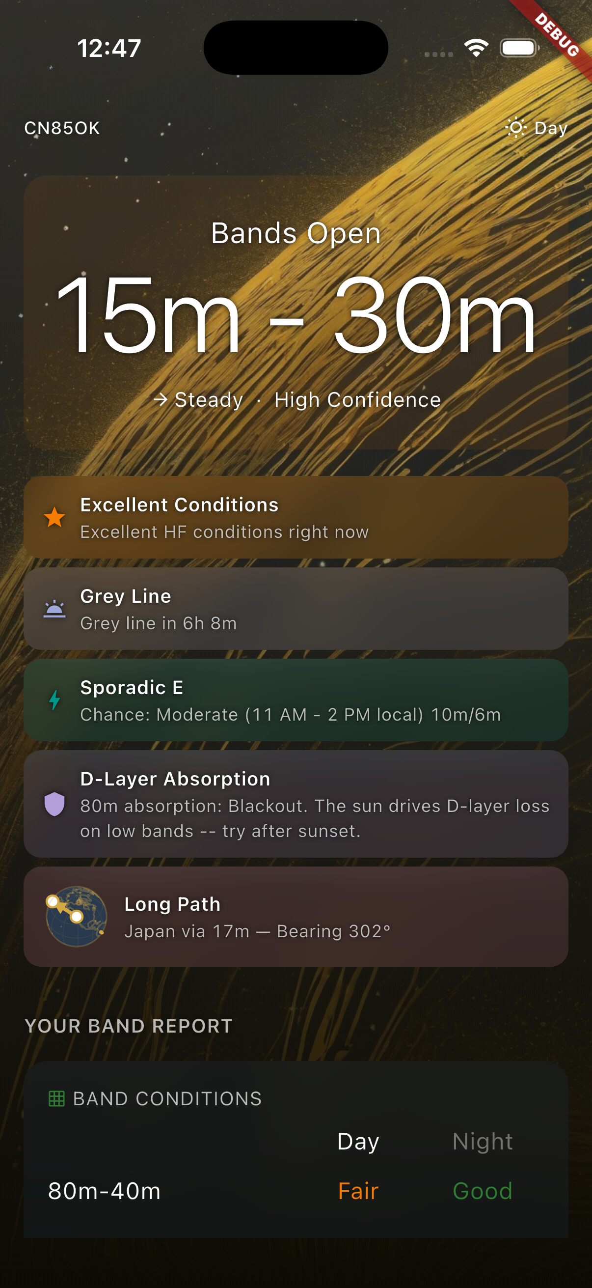
Band Recommendations That Actually Help
Not just "conditions are fair." SkyWave tells you which specific band is your best bet, with a confidence score and a plain-English explanation of why.
Tap "Why this band?" and see exactly which factors went into the recommendation. Solar flux, K-index, MUF, time of day, your location. All of it explained in terms that make sense.
Real-Time Space Weather Dashboard
Ten solar and ionospheric metrics, updated live, with visual gauges and 6-hour trend charts. Solar flux, K-index, A-index, X-ray flux, geomagnetic field, solar wind, Bz polarity, MUF, foF2, and sunspot number.
Every metric includes an education card that explains what it is, why it matters, and how it affects your signal. SkyWave doesn't just show you the data. It teaches you what it means.
Catch Conditions You'd Otherwise Miss
Propagation windows don't wait for you to check the app.
Grey Line Detection: Know exactly when the sunrise/sunset terminator crosses your QTH, with a countdown and an interactive 3D globe.
Sporadic E Alerts: Seasonal and diurnal likelihood scoring so you're ready when 10 meters opens up in June.
Storm Recovery Tracking: When a geomagnetic storm hits, SkyWave tells you when conditions are likely to recover.
Aurora Detection: High-latitude operators get a heads-up when auroral propagation is possible.
NVIS Analysis: See when Near Vertical Incidence Skywave conditions support regional contacts on 40 and 80 meters, with D-layer absorption factored in.
Long Path Propagation
Wondering if you can work that DX station on the other side of the planet? SkyWave scores long path viability across multiple bands, shows you the great-circle path on an interactive globe, and ranks your best targets by confidence.
Two projections: a 3D orthographic globe and a flat azimuthal equidistant map centered on your QTH. The classic ham radio perspective.
Built for Operators in the Field
Whether you're activating a park, setting up on a summit, or operating from the backyard, SkyWave works where you are.
GPS location or manual grid square entry
Save multiple locations and compare propagation across them
Callsign lookup auto-fills your grid and license class
Share your conditions with other operators via a share card with QR code
Learn While You Operate
SkyWave was built with new General and Extra class operators in mind. Every screen is an opportunity to learn something about how HF propagation works.
15+ metrics with plain-English definitions and thresholds
"Why this band?" breakdowns that connect solar data to your antenna
Educational content woven into every detail screen, not buried in a help menu
Pro: Operate Smarter
Free users get the full band recommendation engine, every metric, all educational content, and dark mode. No artificial walls around learning.
Pro is for operators who are actively on the air and want real-time intelligence that catches fleeting conditions.
Pro FeatureWhat It Does For YouSmart AlertsPush notifications when your band opens, grey line approaches, or rare conditions appear. Propagation windows are short. Alerts make sure you don't miss them.Auto-RefreshConditions update every 15 minutes without pulling to refresh. Set it and monitor.Location OverrideCheck propagation from any grid square. Plan your next POTA activation before you drive there.Sparkline TrendsSee where conditions are heading, not just where they are now. Decide whether to stay on or pack up.Morning BriefingWake up knowing if today is worth getting on the air. A daily push notification with your personalized band outlook.Unlimited HistoryTrack your conditions over weeks and months. Spot patterns. Correlate with your logbook.Unlimited LocationsHome station, club, field locations. Switch between them instantly.QRP ScoringFine-tuned operating windows optimized for low-power work.Golden HoursKnow exactly when your best operating windows are today, based on your style and location.
FAQ
Is SkyWave free? Yes. The free tier includes the full band recommendation engine, all ten solar metrics, every educational card, dark mode, and manual refresh. You can use SkyWave without paying anything and still get real value.
What does Pro add? Push notifications for band openings and conditions, auto-refresh, location override for field planning, sparkline trends, morning briefing, and unlimited history and saved locations. Pro is for operators who want real-time alerts and planning tools.
Where does the data come from? NOAA Space Weather Prediction Center for solar and geomagnetic data. KC2G for real-time ionospheric measurements (MUF/foF2). HamDB for callsign lookups. All data flows through our Cloudflare proxy with tiered caching to stay current without hammering the sources.
Does SkyWave work offline? SkyWave needs an internet connection to fetch current conditions. Cached data stays available briefly if you lose connectivity. Expanded offline support for field operators is on the roadmap.
What about VHF and 6 meters? Coming in a future update. The current version focuses on HF bands (160m through 10m).
I'm a new ham. Will I understand this app? That's exactly who we built it for. Every metric and recommendation includes a plain-English explanation. You don't need to know what the K-index is before you open SkyWave. You'll learn it by using the app.
What platforms are supported? iOS and Android.
Built by Johnston Software & Services LLC, Portland, Oregon.
SkyWave is not affiliated with NOAA, ARRL, or any amateur radio organization. Solar and ionospheric data is provided by NOAA SWPC and KC2G. Propagation recommendations are estimates based on current conditions and should not be relied upon as guarantees of radio communication.